Results for "Ancient City"
Pavlopetri, Greece’s Ancient Underwater City


Pavlopetri (or “Paulopetri”) is a small islet off the coast of Laconia in the southern Peloponnese, where ancient history meets the endless blue of the Mediterranean Sea.

This lovely place, which remains almost completely unknown to the majority of people, hides one of the most amazing stories in Greek history, since it is the oldest ancient Greek city that has ever been discovered underwater.

Its name, which literally translates to ”Paul’s Stone,” is directly related to St. Peter and St. Paul, the two greatest Christian apostles and martyrs, who traveled far and wide spreading Christianity during the first century AD.

The city’s long history, however, stretches nearly 5,000 years back into antiquity, since the broader region was known to have been inhabited during the earliest years of Greek history.

Discovered in 1967 by Nicholas Flemming, this ancient Greek town is now the oldest underwater “lost city” in the Mediterranean Sea — and one of the oldest such cities anywhere on the globe.

The year after Pavlopetri’s discovery, in 1968, archaeologists from the University of Cambridge in the UK visited this extraordinary place to map the entire location and to determine the extent of the ancient lost city.

At first, the scientists believed that their discovery was originally of a Mycenaean-era city, but later research revealed that it was actually much older.

More specifically, scientists were able to determine that Pavlopetri was first inhabited in 2800 BC, after elements dating back to the Bronze age were found and identified.

Perhaps the most unique feature of this area is that up until now, its overall layout has remained intact, making it a location of extraordinary importance to archaeologists.

Researchers believe that the city was submerged after a series of three cataclysmic earthquakes occurred in the area around 1000 BC.

These violent seismic events, which led to the city never being able to re-emerge from the bottom of the sea, played a crucial role in maintaining its original characteristics.

Untouched by human intervention, its secrets have remained unknown for thousands of years.

Just over the last decade, new state-of-the-art technology has enabled scientists to discover that the underwater city is comprised of at least fifteen large buildings, lying approximately four meters (13 feet) under the surface of the sea.

Now there are hopes that modern technology will further assist scientists to uncover even more hidden mysteries of this ancient world, making it more widely known and possibly even accessible to visitors via organized tours.


Mehdi Qazi Thursday, April 15, 2021
Egypt breakthrough: Mythical Pharaoh city found 'perfectly preserved' below Nile exposed
(Image: AMAZON)

EGYPT archaeologists were stunned when what was believed to be a mythical sunken city of the Pharaohs was found hiding beneath the Nile in a huge breakthrough in understanding the ancient civilisation.

Mentioned by many chroniclers in antiquity, including Herodotus, the city was said to have been visited by the mythical Greek legends of Alexander and Helen of Troy during the Trojan War. They sought refuge from the Pharaoh after their flight from the jealous Menelaus but were rebuffed by Thonis, the watchman at the entrance to the Nile. According to accounts, a great temple was built at the spot where Heracles first arrived in Egypt, renaming the Egyptian town of Thonis to become the mythical Heracleion.

All physical traces of this city had seemingly been wiped off the map, leading experts to believe it was just an ancient myth.
That was until mathematician Franck Goddio became hooked on the possibility of finding it, it was revealed during Amazon Prime’s ‘Egypt: A Sunken City’ documentary.
The 2012 series revealed: “Off the coast of Egypt, northeast of Alexandria, seven kilometres out, there was said to be a giant secret slumbering under the surface of the water.
“This used to be the Nile Delta, dotted by islands, but over the past 2,000 years, these islands have mysteriously disappeared.
“The ancient texts that remain speak of a place called Heracleion and also a place called Thonis.
“Frenchman Franck Goddio first stumbled across this mystery some 30 years ago, he met an archaeologist who told him there could be sunken cities in Abu Qir Bay and from that moment, Franck Goddio was hooked.”
The series went on to detail how evidence of this ancient city was first spotted during World War 2, but it took years for Mr Goddio to find any physical trace.
It added: “Back in the Forties, a pilot described seeing strange shapes as he flew over the area, but nobody seems to be interested.
“Goddio focuses on his strengths as a mathematician and statistician, spending days in front of his laptop, seeing the mystery as a calculable mathematical problem.
“Using an electromagnetic dragging technology, Goddio had the base, but it takes years of the research boat cutting back and forth according to a very precise plan.
“But his strict procedure does deliver results, entering all the details into his computer he puts together a complex visualisation of the seabed and there are some unusual features.
“He puts together an international team of scientists and divers, initially finding nothing, but finally, the divers make a discovery – large limestone blocks arranged next to each other.”
The series detailed how Mr Goddio began to piece together the possibility that he had found the ancient city, seeking expert opinion for help.
It added: “His methods seemed to work, the location of the walls seemed to correspond to the measurements already taken.
(Image: AMAZON)

(Image: AMAZON)

“Finally, Goddio is convinced that he’s discovered the legendary port, the city is clearly more than just a famed myth.
“He goes to get some academic back-up, approaching respected researchers at Oxford University’s Institute for Archaeology.
“Professor Sir Barry Cunliffe is one of the world’s leading archaeologists and his colleague Professor Andrew Wilson specialises in maritime trading in antiquities, they are stunned by what he told them."
Finally, Mr Goddio found evidence of an ancient temple, which was said to be at the centre of the city.
He could then start mapping the rest of the area out.
The series explained: “The international team of archaeologists set off on further expeditions to Egypt, dividing the seabed into a number of squares so they know exactly where they are in the murky water.
“Where they believe the Temple of Heracleion should be, they discover a large monolith, perfectly preserved, a shrine to Amun-Gereb.
“What the divers find next surpass their wildest expectations, three colossal statues, broken into just a few pieces, but otherwise in a surprisingly good condition.
“They are clearly of a Queen and a Pharaoh, the third is the god of the waters of the Nile, magnificent images from the Ptolemaic dynasty that ended in 30BC.
“Having made these finds, Goddio was able to reconstruct the legendary temple, the site provides answers that can’t be found in the history books.”
Heracleion was originally built on some adjoining islands in the Nile Delta, it was intersected by canals, a number of harbours and anchorages and the countries main trading port in the late period of ancient Egypt.
During the time when the city especially flourished between the 6th and 4th centuries BC, a large temple of Amun-Gereb, the supreme god of the Egyptians at the time, was located in the middle of the city.
Pharaoh Nectanebo I made many additions to the temple in the 4th century BC and many sanctuaries were dedicated to Osiris and other gods who were famous for miraculous healing and attracted pilgrims from a wide area.
During the 2nd century, BC Alexandria superseded Heracleion as Egypt’s primary port and over time the city was weakened by a combination of earthquakes, tsunamis and rising sea levels.
At the end of the 2nd century BC, probably after a severe flood, the ground on which the central island of Heracleion was built succumbed to soil liquefaction.
The hard clay turned rapidly into a liquid and the buildings collapsed into the water.
Express.co.uk

Web Thursday, June 4, 2020
Archaeologists discover possible ancient ‘shrine’ to Rome’s legendary founding father

Italian archaeologists have discovered what they say could be a lost, millennia-old shrine dedicated to Rome’s fabled founding father Romulus.
Excavations in the Roman Forum, in a chamber beneath the ancient senate house, have unearthed two objects that, while humble in appearance, may have been of great historical significance.
The first resembles a washtub, which excavators believe is a sarcophagus or coffin. The other is a cylindrical stone block thought to be the partial remains of an altar.
The recently excavated area “represents a place, which in history and in the Roman imagination, speaks about the cult of Romulus”, said archaeologist Patrizia Fortini.
As the legend goes, Romulus and his twin Remus – born to the god of war and daughter of a neighbouring city’s deposed king – were ordered to be thrown into the Tiber river by the new king, but were instead abandoned by its banks and rescued by a wolf, who suckled them until they were found by a shepherd.
After restoring their grandfather to the throne, they set out to build their own city, but a disagreement about which of Rome’s seven hills to build upon saw a rift appear between them.
Romulus claimed to have won via divine approval, building upon Palatine Hill and becoming the city’s first king circa 753 BC. Romulus later murdered his brother in a dispute.
While Rome’s origin story is heavily disputed, some ancient sources claimed Romulus was buried in the area of the find. The sarcophagus likely dates to some 200 years after the twins’ time.
It is not known even "whether Romulus physically existed” the way he was described in legends, Ms Fortini said, adding that nobody is hypothesising the sarcophagus ever actually contained Romulus’ remains.
Alfonsina Russo, the archaeologist in charge of the site, noted that according to some ancient traditions Romulus was killed and chopped to pieces, or ascended
“Therefore, this cannot be his tomb, but it is very likely, we believe, that this is a memorial site, a cenotaph,” Ms Russo added.
Curiously, it is the second time the sarcophagus and cylindrical stone stub have been unearthed, but it is only now that archaeologists are deeming them important.
In 1899, an Italian archaeologist, Giacomo Boni, was the first to systematically excavate the area. 
In his writings, he described finding the cylindrical stone and “a rectangular, tub-shaped crate in tuff” – a rock out of which both objects are made, carved from the Capitoline Hill. 
Boni attributed no particular importance to his finds, and in the 1930s, during the regime of dictator Benito Mussolini, a monumental staircase to the senate house – called the Curia Julia – was built over the site.
“We thought it would have been destroyed," Ms Russo said. 
But Fortini’s intuition told her that what Boni had found was likely a shrine to Romulus, since the area is one associated with the origins of Rome, and she sought to excavate there. Another crucial clue for where to dig was the close proximity of a black marble shrine called the Lapis Niger. 
One of the oldest relics in the Forum, the Lapis Niger was long believed by some Romans to mark either Romulus’ grave, or the spot where some claimed he was murdered by the senate.
While excavations continue, authorities hope the public will be able to stroll underground to view the discovery by 2022.

Web Saturday, February 29, 2020
The Ruins of a Massive Ancient City Have Been Discovered in Guatemala

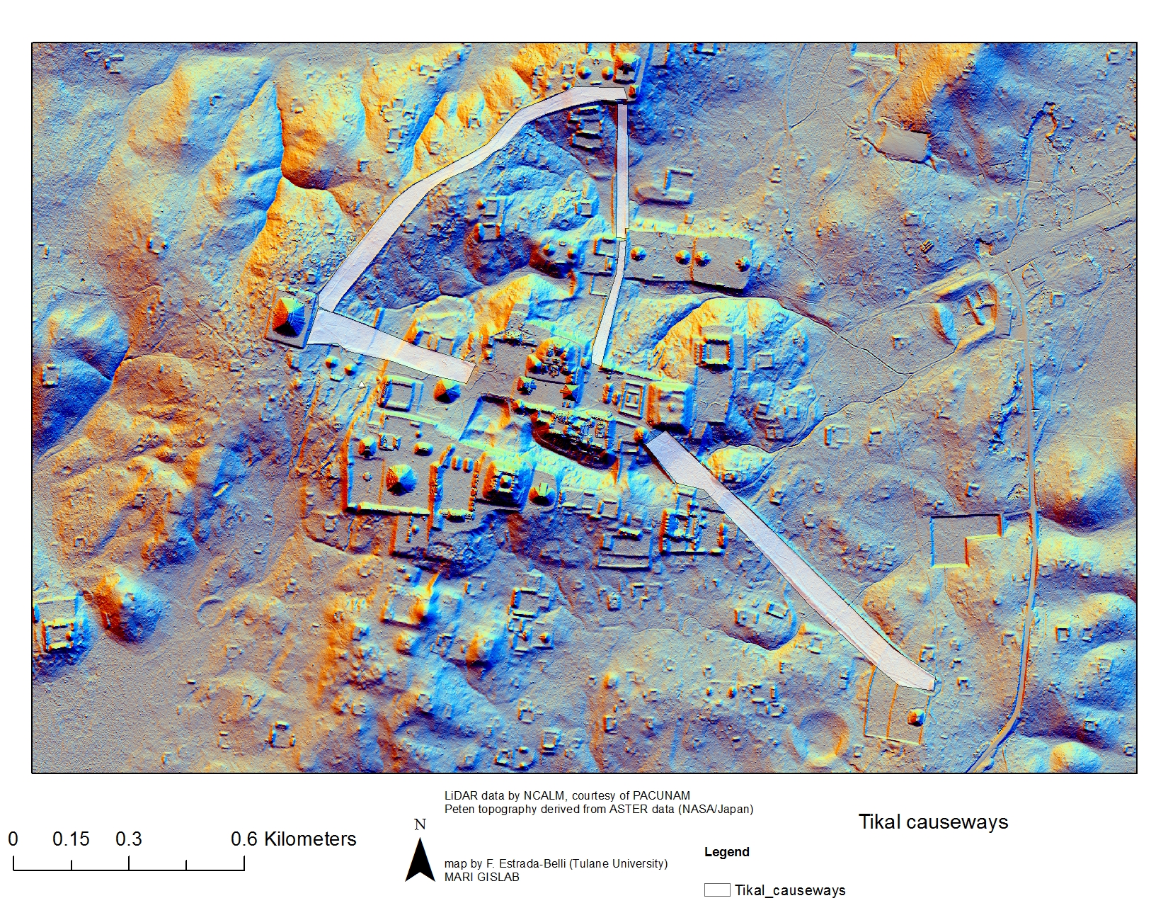
The ruins of an enormous Maya ‘megalopolis’ have been discovered in Guatemala with the help of the remote sensing technique LiDAR, according to a bombshell exclusivefrom National Geographic on Thursday. This vast lost city envelops sites like Tikal, Holmul, and Witzna—known for their temples and pyramids—but shows that these famous heritage areas are the tip of the iceberg of this lost urban network.
Hidden under the dense jungle canopies of the Maya Biosphere Reserve, more than 60,000 human-made features—homes, canals, quarries, highways, and more—have been identified in aerial imagery collected by an international collaboration of researchers headed by the PACUNAM Foundation, a Maya cultural and natural heritage organization.
This pre-Columbian civilization is estimated to have peaked some 1,200 years ago. The data suggests it may have supported a population of 10-15 million over the newly surveilled area of 800 square miles (2,100 square kilometers).
The advanced infrastructure, which includes agricultural terracing and elevated trade routes to prevent flooding in rainy seasons, has experts rethinking the dimensions and complexity of the Maya empire.
These ancient peoples obviously established a robust and imaginative culture based on their known relics, but the new research has revealed that the scale of this lost society is far beyond what experts had imagined. The findings will be explored in an hour-long documentary called "Lost Treasures of the Maya Snake Kings," premiering Tuesday, February 6 on the National Geographic Channel.

A new pyramid found south of Tikal’s Mundo Perdido. Image: PACUNAM/Canuto & Auld-Thomas
This breakthrough was possible thanks to LiDAR (Light Imaging, Detection, And Ranging) sensors, which can survey landscapes in 3D by bouncing laser pulses off the ground from drones and other aerial vehicles. LiDAR is exceptionally useful for detecting archeological sites, as it penetrates through jungle cover and other features that hinder exploration on the ground.
The technique has been the catalyst of many discoveries in recent years, including major finds at Angkor, Cambodia and Caracol, Belize. Given that the newly announced Maya “megalopolis” is the result of the first phase of PACUNAM’s LiDAR Initiative, which began in 2014, there are likely to be many more revelations about the mysterious people who built this massive urban network. The ultimate goal is to survey 5,000 square miles (14,000 square kilometers) of Guatemala’s lowlands with LiDAR sensors.
“There are entire cities we didn’t know about now showing up in the survey data,” Francisco Estrada-Belli, a National Geographic Explorer and one of the lead archeologists on the project, says in NatGeo’s forthcoming documentary.

“There are 20,000 square kilometres more to be explored and there are going to be hundreds of cities in there that we don’t know about,” he added. “I guarantee you.”

Mehdi Qazi Saturday, April 13, 2019

Facebook